I headed back into the city on foot for the first time since my insipid exodus. When walking across an urban or suburban expanse through which I have bussed and driven as a passenger along the mass transit grid and road network, I began looking for the tweener spaces, the secret pathways of child kind. Motorists, especially young ones dependent on GPS navigation, are forever astonished that I, a non-driver, usually know a better way to go, although my awareness of one-way streets is less than perfect as they’re all two-way for this ambling urban ape.
I seek such creases in the adult world by using the sun and moon as my guide and walking as near as the crow flies as I might without trespassing in private yards. This sometimes leads to a detour or course reversal and occasionally a misadventure. But generally it serves me well.
This walk from Towson to Northeast Baltimore would take me across exactly 4 miles in a southeasterly direction. However, to walk the transit grid like a dindu would make 6 miles and tracing a driving course would make it 4.5.
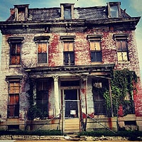
After crossing Loch Raven Boulevard from the haunts of my dead childhood, I knew that cutting left through the Rec Center would dump me into a low spot, where low income housing abounded and necessitate a hump over the hill straddled by Hillsway and down into another low income lowland gully, up over another rise and then through more low-lying, low-income housing. It occurred to me then that big men still live on the hill and little men still skulk at its base.
As I normally do I followed the terrain, which is still visible if you ignore all of these meat-puppet boxes and use alleys and greenspaces.
Arriving at a street that runs parallel with the ridge I wished to navigate down to the old covered streambed called Perring Parkway, I had a choice of walking the grid and losing a mile or cutting through an alley in hopes that there was a path connecting the parallel road with Hillendale, which traces the west flank of the ridge I wished to walk along. And there it was, a wooded lane comprised of a concrete sidewalk, flanked by oaks two deep on either side, making a green space 30 feet wide by 200 feet long. When I got to the other side of this oak-shaded lane I saw that it was signed as property of the Baltimore County Recreation and Parks Department, though it did not warrant a name, though I’ll call it Mudway. Thrilled by the specter of foul deeds, drug deals, rapes and murders that will one day be committed here, I continued my jaunt, aware now—a few decades too late for my own good—that all the shit properties that got ghettoized first sat low in the belly of the land and the good homes who held out long enough to earn iron bars and security systems sat along the shoulders, brows and crowns of the limply hilly terrain.
Walking is still a pleasure and, ever mindful of approaching trouble spots from high ground, allowing me to stroke down, I wondered all along the way, Might packs of feral canines and humans one day come this way in Man’s sloth-earned end of days?
White in the Savage Night: A Politically Incorrect Life In Words: 2016
link › jameslafond.blogspot.com